Articles in this Volume

Research Article Open Access
Rising Summer Temperatures in Guangzhou: Trends, Risks, and Responses
Article thumbnail
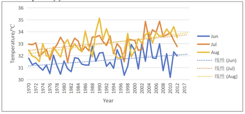
Global warming is significantly altering the patterns of extreme weather events, with extreme heat exerting an especially urgent impact on densely populated urban agglomerations. This paper focuses on Guangzhou, a core city in China's Pearl River Delta (PRD), as a representative case. Based on monthly maximum temperature data from 1970 to 2020 provided by the U.S. National Oceanic and Atmospheric Administration (NOAA), this study analyzes the long-term characteristics of summer high temperatures in this region. It shows that over the past 51 years, the average summer (June-August) maximum temperature in Guangzhou has exhibited a significant upward trend, with a linear warming rate of approximately 0.25°C per decade. Further research reveals that warming is asynchronous across the summer months, with August showing the most pronounced warming rate. This trend serves as the fundamental climatic background for the increasingly frequent and intensified extreme high-temperature events in the PRD region. Integrating existing literature, this paper demonstrates that continued warming poses compound risks to regional public health, the ecological environment, and socio-economic functioning through multiple pathways, such as intensifying the urban heat island effect, altering the ecology of infectious disease vectors, and increasing the potential for photochemical pollution.
Show more
Read Article PDF
Cite
Research Article Open Access
A Review of Direct Ex-situ Carbon Dioxide Mineralization Technology Focusing on Techno-economics
Article thumbnail
Direct ex-situ CO2mineralization converts CO2into stable carbonates by reacting with Ca/Mg-rich feedstocks in engineered reactors, offering permanent storage with low leakage risk. This review evaluates feedstocks (natural silicates and industrial alkaline wastes) and compares their sequestration capacity, kinetics, and techno-economic factors. We summarize key process intensification methods, including mechanical/thermal pretreatment and recyclable solvents that enhance CO2dissolution and enable cyclic operation. Mechanistic evidence indicates that silicate dissolution is commonly rate-controlling, and conversion is controlled by coupled effects of particle size, temperature, CO2partial pressure, ionic strength, and mixing. Finally, TEA frameworks and engineering cases are discussed to clarify the deployment opportunities in construction materials, etc. Challenges lie in accelerating kinetics under mild conditions, controlling product quality, and reducing site-dependent cost uncertainty.
Show more
Read Article PDF
Cite
Research Article Open Access
Spatial Distribution Pattern and Influencing Factors of Petromyzontiformes Worldwide
Article thumbnail
As the most primitive extant jawless vertebrates, Petromyzontiformes have an evolutionary history dating back hundreds of millions of years, with approximately 50 known extant species globally, mainly distributed in temperate and frigid waters across all continents except Africa. They hold irreplaceable value as model organisms in vertebrate evolution research due to their unique biological characteristics such as the origin of the "new head" structure and central nervous system regeneration ability. Petromyzontiformes are highly sensitive to environmental changes, and their migratory behavior and population dynamics are jointly affected by ecological factors and human activities. In this study, we analyzed the global spatial distribution pattern of Petromyzontiformes, which presents a distinct antitropical distribution feature, concentrated in the temperate zones of the Northern Hemisphere and the mid-to-high latitudes of the Southern Hemisphere. We further explored the key environmental factors restricting their distribution, including water temperature, water quality, flow velocity, substrate type and salinity, among which low tolerance to high water temperature is the primary factor restricting their expansion into tropical regions. In recent decades, human activities such as habitat fragmentation, water pollution, overfishing and climate change have severely threatened the survival of Petromyzontiformes populations, leading to the contraction of distribution ranges and even local extinction risks for some species, while a few species have caused serious ecological damage as invasive species. This study also summarized the current research methods for Petromyzontiformes distribution, including field sampling, environmental DNA technology and species distribution models, and highlighted key research gaps such as the lack of multi-factor interaction analysis and long-term monitoring data. Finally, we proposed future research directions and conservation strategies, aiming to provide scientific basis for the protection, habitat management and restoration of Petromyzontiformes, and to safeguard the biodiversity and evolutionary research value of this ancient vertebrate group.
Show more
Read Article PDF
Cite
Research Article Open Access
The Relationship and Role of Remote Sensing in Geological Exploration
Geological exploration contributes to the development of resources, construction, and the prevention of disasters. The benefits of the remote sensing technology are extensive, effective, and non-contact, and they can swiftly and precisely offer information regarding geological exploration. The paper describes the relationship and role of remote sensing and geological exploration, considering three ways of geological exploration, namely, geological hazard prediction, regional geological mapping, and mineral resource prediction, and concludes. The studies have established that remote sensing technology has significant applications in predicting geological hazards, geological mapping of most of the regions, as well as predicting mineral resources. Regarding geological hazard prediction, remote sensing technology, which has its benefits, assists the researcher in detecting several geological hazards that are hidden. The information gathered using the remote sensing technology has a scientific ground through which the government can develop disaster prevention and reduction strategies. Remote sensing technology has also emerged as one of the most significant tools in the geological mapping of regions. The rich remote sensing information offers information to underpin the geological mapping study in the region, thereby rendering it accurate and precise. Remote sensing has recorded positive performance as an auxiliary tool in predicting mineral resources in this regard.
Show more
Read Article PDF
Cite
Research Article Open Access
Study on Ecological Security Pattern Construction of the Middle Yangtze River Urban Agglomeration from the Carbon Sequestration Enhancement Perspective
Article thumbnail
Against the background of the "dual carbon" strategy and ecological civilization construction, this study takes the middle reaches of the yangtze river Urban Agglomeration as the research area and uses 2020 multi-source data to construct a carbon sequestration-optimized ecological source system. We comprehensively applied Morphological Spatial Pattern Analysis (MSPA), ecological environment quality assessment and InVEST model-based carbon stock assessment, then formed an optimized resistance surface by superimposing multi-factor resistance surfaces and correcting with carbon sequestration importance. Ecological corridors and pinch points were identified via circuit theory to establish an ecological security pattern from the perspective of carbon sequestration enhancement. The results show that carbon sequestration constraints reduced ecological sources from 1344 to 377, with only a 10.7% drop in total area and more concentrated distribution in high carbon sequestration regions. High-quality ecological areas cluster in mountain forest zones with an obvious ecological gap in the Jianghan Plain, and high-value comprehensive resistance surfaces distribute around provincial capitals. We identified 895 ecological corridors and 60 ecological pinch points . Overall, this study gives a spatial basis for the agglomeration to implement the "one core, two lakes, four rivers, five screens and multiple spots" ecological pattern.
Show more
Read Article PDF
Cite
Research Article Open Access
Comparison of Surface Energy Balance Between Polar Sea Ice and Mid-to-Low Latitude Regions
Article thumbnail
The actuality of Earth's Energy Imbalance is extremely associated with global warming and sea level rise, with a more noticeable warming trend being observed in the Arctic region. The aim of this study is to quantify the effects of various climatic factors on radiation at different latitudes in the Northern Hemisphere through the utilization of satellite and reanalysis datasets, in order to recognize the primary driving factors for the situation of global energy imbalance. Through the utilization of the ordinary least squares method and the random forest method, an analysis was conducted of the effects of sea ice concentration, sea surface temperature, cloud cover, atmospheric water vapor, and aerosols on the top-of-atmosphere radiation in the mid-low latitudes (0°-70°N) and high latitudes (70°-90°N) regions. It is indicated by the findings that in the mid-low regions, the main drivers of radiation are identified as cloud cover and aerosols, and in the high-latitude areas, obvious influences on radiation are exerted by the effects of TCC and AOD, but a notable increase is observed in the contribution of TCWV. Meanwhile, a critical role in shortwave radiation and net radiation is also played by sea ice concentration. However, a clear identification of the main driving factors behind the warming trend in the Arctic region is failed to be achieved by the research. The incorporation of more variables related to atmospheric dynamics with a larger time span can be made by future studies, and the time lag effect can be taken into account to better assess the impact of sea ice concentration on radiation.
Show more
Read Article PDF
Cite
Research Article Open Access
Ecological Impact of PVC Microplastics on Microbial Communities in Wet Waste Treatment Systems
Article thumbnail
The ecological impact of PVC microplastics on the microbial community in the wet waste treatment system mainly comes from three joint effects: particle persistence, microbial colonization of particle surfaces, and the continuous release of chemicals such as additives under high humidity, strong microbial activity and fluctuating physicochemical conditions. Compared with the relatively inert polyolefins, PVC contains chlorine-containing main chains and often contains plasticizers and stabilizers, so it is more likely to trigger physicochemical stress caused by particle surface interaction and additive release at the same time. This review focuses on the occurrence, transport, and fate of PVC in the process of pretreatment, aerobic composting and anaerobic digestion, focusing on surface aging, preferential microbial colonization, and the differences between attached communities and bulk-phase microbial communities. Studies have shown that the impact of PVC microplastics on wet waste treatment systems is not a single exposure effect, but the result of surface aging, interface colonization, additive release and co-pollutant coupling. These processes ultimately alter microbial community structure, functional organization, and overall treatment performance, particularly by disrupting key metabolic pathways involved in methane production. In general, PVC is more likely to be enriched in the solid phase and persists throughout the treatment process; its additive leaching is obviously time-dependent and strongly affected by environmental conditions. This suggests that microbial communities are more likely to experience chronic stress than transient disturbance. Future research should focus on how PVC properties and additive release interact under real operating conditions, and further clarify the mechanisms by which they affect microbial community structure, function, and treatment performance.
Show more
Read Article PDF
Cite
Research Article Open Access
Research Progress and Prospects of GIS-Based Studies on Spatio-Temporal Patterns of Landscapes in China
Research on the spatio-temporal patterns of landscapes is crucial for understanding the complexity of human-land relationships. With the in-depth application of Geographic Information Systems (GIS) technology, the research paradigm in this field has undergone significant evolution, progressing from static pattern identification to dynamic process simulation and expanding towards multidimensional frontiers. This paper systematically reviews the recent applications of GIS in landscape studies in China. At the level of pattern identification, methods of spatial visualization and quantification have revealed the spatial differentiation rules of cultural landscapes, ecological elements, and urban-rural settlements. At the level of process simulation, dynamic models and multi-source historical data have enabled the mechanistic analysis and process reconstruction of urban expansion, landscape evolution, and historical spatial reconstruction. At the level of frontier expansion, the integration of 3D GIS and interdisciplinary methods has deepened research from two-dimensional planes to three-dimensional spaces and from single analyses to integrated simulations. Despite significant progress, current research still faces challenges in integrating historical data, improving the accuracy of 3D models, and intelligently fusing multi-source data. In the future, deepening the application of 3D technology, promoting AI-driven intelligent analysis, developing interactive simulation platforms, and strengthening interdisciplinary methodological innovation will be key directions for advancing research on landscape spatio-temporal patterns to a deeper level.
Show more
Read Article PDF
Cite
Research Article Open Access
Research Progress on the Transformation of Primary Constituents in Aged Tea and Its Impact on Flavor Quality
The aging of aged tea at long term storage is a continuous quality evolution process leading to systematic transformation of main internal substances, thus determining the development and evolution of its flavor quality. However, the current work does not extensively investigate the dynamic transformation rules of key components in the aging process, their synergistic effects, and their intrinsic relationship to flavor quality, nor does the related knowledge appear sufficiently comprehensive or systematically established. In this article, we comprehensively review the transformation pathways and reaction properties of core internal substances including tea polyphenols, amino acids, and alkaloids in aged tea during long term storage; discuss in detail the specific impact of transforming different components on key flavor characteristics such as aroma and taste; and further study the complex network relationship model of synergistic effect between various components, aiming to provide more solid theoretical support and precise scientific guidance for targeted control of flavor and sharp quality improvement of aged tea.
Show more
Read Article PDF
Cite
Research Article Open Access
Linking Typhoon Trajectories, Exposure, and Economic Losses: An Impact-Oriented Analysis for Japan
Article thumbnail
Tropical cyclones cause significant economic losses in Japan, where high population density and concentrated assets make impacts uneven across regions. This study builds an impact-oriented framework to explain why losses differ between events by linking typhoon tracks, regional exposure, and observed socio-economic losses. Typhoon tracks are classified using a hierarchical, rule-based method that combines simple shape features with spatial contact indicators. A composite loss indicator is constructed from population, housing, and agricultural losses. Event impacts are modeled with a parsimonious hazard–exposure regression using typhoon intensity, land-contact intensity, and a PCA-based exposure index. According to the findings, a different pattern of exposure has been shown to be related to each trajectory type, whereas trajectory/land interaction influences impact analysis. Specifically, the regression shows that the intensity of the typhoons will primarily drive loss on the east-side; however, contact with land and exposure to hazards will have a much less stable and smaller effect on overall loss results. Cross-validation demonstrates that the study's framework provided reasonable and interpretable descriptions of loss differences based on small sample sizes.
Show more
Read Article PDF
Cite